I have recently returned from a second visit to Lake Kerkini in Northeastern Greece. I blogged quite extensively about my first visit in Jan 2025, so you might also be interested in looking at the first blog in that series. Primarily, these trips are about getting out on the lake in boats, seeing birds in their natural environment.
In January, the water level was low, and the dominant species that I saw were pelicans – Dalmatian and great white.
In May, the lake with its birdlife is very different from January. This time, the water level was much higher, and the birdlife was vastly different. Both species of pelicans were still there, but many of them were on their breeding platforms, which we did not approach. A few pelicans came near us, but for the most part, I saw birds such as herons (grey, squacco and black crown night), egrets (great, little and cattle), cormorant (great and pygmy), grebes (great crested and a smaller one that I couldn’t readily identify), black kite, stork, marsh harrier, and spoonbill.
Pelican silhouetted against pre-dawn clouds
Pelicans in the remains of the forest at sunrise
Early morning out on the lake
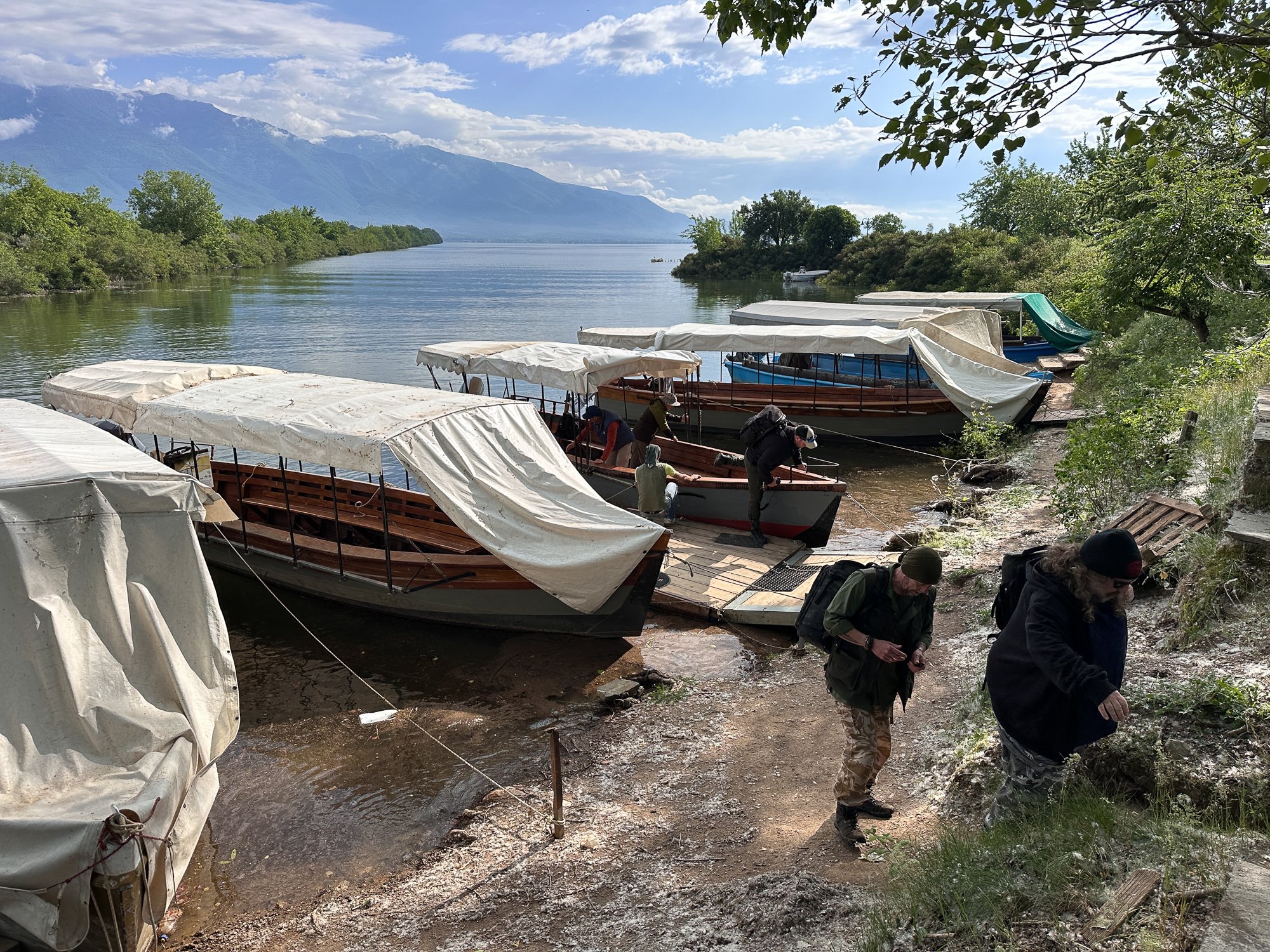
Kerkini harbour: landing after a morning outing
The trip I was on was organised by Wildlife Worldwide and was led, as before, by Sean Weekly: he is a great photographer in his own right and a brilliant expedition leader with exceptional people skills. Sean had organised the same boat as we had before, piloted by Giannis, and with a local naturalist, Babis. As before, we stayed in the Hotel Oikoperiigitis in Kerkini.
In the winter, the boat trips are always freezing cold, and it takes gloves, hats and multiple layers to provide a reasonable degree of protection. This time, it was T-shirt weather during the day, although, at dawn, the wind over the lake as we sailed across was chilly, and I needed a light jacket with a couple of layers underneath. Nonetheless, the outer layers quickly came off as the sun rose.
Pelican seeking prey by the shoreline, dawn
On the first evening we were there, and each morning in time for dawn, we set off across the lake to where the Strymon/Struma river enters it. Heading in that direction, the boat encounters a sunken forest. This is the remains of a forest that has been underwater since the reservoir was formed. It is a wonderful habitat for some of the birds, especially the cormorants, whose nests festoon the trees. Unfortunately, this year, the cormorants had an extremely bad breeding season: with the warm winter, their chicks hatched early, before the fish fry were available for their parents to feed them. Relatively few youngsters made it through this season.
Pelican, cormorants and the remains of the sunken forest
Preening pelican in the remains of the sunken forest
Dalmatian pelican, head detail, non-breeding plumage
Pushing on through the sunken forest eventually, the boat comes to the far side near where the Strymon enters the lake. Here is a low-lying wetland, home to herons, egrets and many others.
Squacco heron and black crown knight heron were lifetime ticks for me; naturally, I was delighted to get to see them. The egrets are familiar from home, but more than welcome to see; likewise, the great crested grebes.
Squacco heron with rainclouds behind
Squacco heron in flight
Cattle egret with spider
Stork in flight
Ah! Coffee! With Kerkini mountains in the background.
One of the other contrasts with the winter trip was that the pelicans were busy feeding themselves without any human help. In the winter, the Dalmatian pelican colony is partially sustained by active feeding from the boats. The low water level in January meant that we could come off the boats to photograph lying flat on mats at the shore side while the pelicans fed. This time, although one or two birds flew alongside us, they always seemed happy to feed for themselves. They were particularly active at the edge of the lake where small fish and amphibians are abundant. The lake also has a large area covered in water lilies where many of the birds hunt. We could hear (but rarely see) frogs around the lilies.
Dalmatian pelican hunting among the water lilies in the first light of dawn
I was told that the sunken forest is rapidly disappearing. Mike and Lee, two of the other English photographers whom I had met on the previous trip, had been out three years previously. They were amazed at how much the forest had simply disappeared. From what I gather, partly this is as a result of intensive buffalo farming in the region. Buffaloes have grazed on the land around what is now Lake Kerkini for 1000 years. But now the buffalo are farmed more intensively than ever. Especially when the water level is low, they chew the new shoots of growing trees and damage the bark of existing ones by rubbing and scratching themselves against them. This seems to be an insoluble problem with the interests of the farmers pitted against the interests of preserving the natural environment.
Bee-eater bringing an insect back to its scrape
Bee-eater flying low over its grassy habitat
In the afternoons, we headed off to various destinations, best of all, twice to a location on the northern side of the Strymon/Struma river, where there is nesting habitat for bee-eaters. I’ve only ever seen them with the naked eye before, but I have never had a previous chance to photograph them. We had two afternoons in pop-up hides within a short distance of the burrows they scrape in sandy ground. They are beautiful, brilliantly coloured little birds that move at extremely high speed, with wings beating so fast as to be invisible to the naked eye, and moving in unpredictable ways, occasionally squabbling with each other, occasionally bringing an insect back to the burrow where the mate awaits.
We also went in search of Balkan wall lizards near Kerkini harbour. I’ve photographed the Madeira wall lizards in Funchal, so it’s nice to see a different species. The males in the breeding season have a brilliant blue chin and a bright green skin elsewhere. The females are camouflaged in brown. Lovely little creatures.
Balkan wall lizard, male
Balkan wall lizard, female
Some technical notes. At the bee-eaters’ hides, I was shooting out 30 frames per second on my Sony A1. I blogged previously about the importance of shooting at the highest possible frame rates with small birds moving unpredictably. Every shot that I got of the bee-eaters showed different wing positions or body angles. Never having photographed them before, I was delighted with what I got, but I can’t help feeling that, given the option, a Sony A9-III with its 120 frames per second would be a great way to go with these birds.
On the other hand, with the water birds out on the lake, I was shooting at 15 frames per second normally. As much as anything, there comes a point where filling up memory cards over multiple hours becomes an unattractive prospect.
All the pictures I took were hand-held. I decided against taking a tripod for two reasons. First, shooting from the small boat is impossible with a tripod: it is too crowded, and the boat moves side-to-side far too much for a tripod to be useful. Second, in the small pop-up hides shared by two people, there is not enough room for the movement you need to follow bee-eaters in flight from a tripod. They move so fast and unpredictably that, for me, going hand-held, even with a lens as big as the Sony 200-600mm, is the only way.
I was shooting with a mixture of different brands of Type A CFexpress cards in my A1. For the bee-eater shots, I used a 256GB Nextorage card that I bought last autumn. It was a great bargain at the time, at about £80. Now it is about three times that price: the great data centre memory grab has seen the prices of consumer memory go through the roof. One of the good things about the Nextorage cards is that they did not get very hot in use. I was shooting intensively, but the cards stayed cool throughout. I also never hit the buffer, although my bursts of pictures (rarely more than 70 per at a time) never threatened that in any case. Given the current price of Type A cards, I won’t be buying any more in the immediate future.
All in all, it was a wonderful visit sampling the habitat in a completely different state than before. Somewhere with as complex an ecosystem as Lake Kerkini rewards multiple visits. I’m sure this is not the last time I will go there.